
New simulation functionalities, streamlining of workflow, and creating more visual impact.
This is our biggest release so far! It encompasses 138 new features and 25 major bug fixes with countless smaller improvements. While it is always great that things are improving, what are these new features really enabling on the customer side? In this article, we will shed some light on just this, exploring the latest advancements on the software frontier and how we see these updates empowering our consultant and engineering users.
New simulation functionalities, streamlining of workflow and creating more visual impact, 2.0 will unlock new possibilities for your business. Fluidit Storm now supports 1D-2D coupling for improved flood risk analysis on your stormwater systems. For Fluidit Heat, we now support the simulation of low-temperature district energy networks. Fluidit Sewer has been improved with the possibility to upgrade basic Sewer to include heat recovery and reclamation. In addition to simulation engine side improvements, a lot has been done in improving the connectivity of the software eg. fetching weather stations automatically (as of 2021 working in Finland only), and adding WFS layers with modified visualization.
With these new features, you can do new technology feasibility analyses for your customers that are more accurate than ever before. Whatever your plans may be, now you can simulate them!
New simulation capabilities
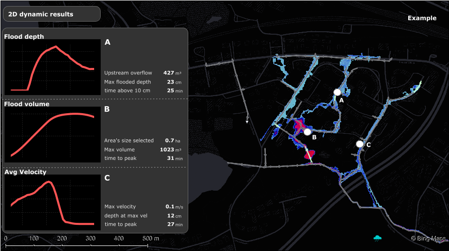
The simulation capabilities of the software have also been extended. Especially for Storm, that has gained the long-waited support for fully-coupled 1D-2D modeling allowing water to flow back and forward from the network (1D) to the surface (2D). The coupling connects the two simulation engines used in Storm: the industry-standard SWMM 1D and the fast inundation model CADDIES (2D). It’s also possible now to query flood results for points, lines or polygon areas defined by the user before the simulation.
New 2D culvert components can now model the transfer of water from one point to another on the surface and the flood model areas now also have spatial varying roughness and horizontal permeability.
The user can now decide to run 2D surface flow simulations on the GPU (OpenCL) for a faster simulation time. The new possibilities of modifying the DEMs on the fly directly in the software also improve the usefulness of the 2D simulations.
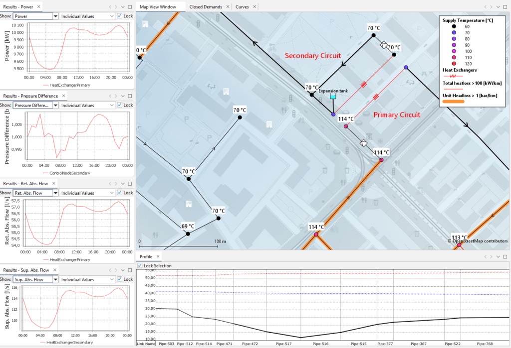
The Fluidit Heat engine now supports a plethora of new features and some new components. These will allow our users to model more complex systems, such as low energy networks (AKA low-temperature district heating – LTDH), whilst heat loss calculations have been improved to also support more detailed simulations.
The Fluidit Sewer simulator has also received updates for modeling heat transfer and reclamation in Sewer networks. If you are interested in heat reclamation from sewer networks, contact our sales team: sales@fluidit.com.
New post-processing capabilities
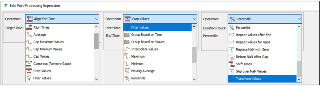
The schematic view has gained the functionality to select the visualized time range. The time range can be dynamic:
- Based on the model’s simulation start time e.g. shift time series 24h from the model’s simulation start date
- based on the clock times (e.g. align time series end to the current clock time)
- Calculate based on fixed dates and times (e.g. align result’s start time 5 days from 2019-10-5).
The schematic view components now allow limitless time series data processing using the time series post-processing blocks, edited via informative and visual UI.
There’s now even more flexibility for the user as it is possible to manage how external data (e.g. SCADA), internal data (e.g. time series), and model results are displayed and handled. As it is possible to define dynamic time range and post-processing strategies, our users can now combine data from different sources to create informative charts on the system’s past, current, and future conditions as the example below.
This infrastructure makes Fluidit software also an operational tool where all the information comes together, is processed, and displayed in real-time.
Input and supportive data
Our quick and easy importing tools have improved even more, and so has handling external raster and vector data. Now it is possible to use vector sources with multiple layers (e.g. GeoPackage) to import data as components to the model or to add as background layers. Improvements to the raster layer handling provides an even faster and more memory efficient experience.
DEMs are now scenario-specific which allows, for example, analyzing the impact of different ground elevations. DEMs can also be created (natural neighbors interpolation) from any vector data (e.g. LiDAR generated point data). Contour layers can be created directly in the software from any raster layer, allowing our users to quickly leverage their available data.
DEMs can be modified on the fly directly in the software using the DEM modification tool.
Sometimes our users wish to export the nice background layers created in our software. Now, this is possible with two clicks! Simply right-click on any background layer to access the export actions! Vector layers can be exported as contours and any elevation layer, heat map, or other raster type background layer, as geocoded tiff.
Users in Finland can now enjoy data fetching and generation tools. Historical data from the Finnish Meteorological Institute (FMI) weather stations can be downloaded in simply a few clicks directly from Storm, Sewer or Heat. In the near future we expect to have global coverage of historical weather station data.
Storm users also have a Design Storm generator tool with multiple return periods and patterns (default database initially for Finland, but other design storms can be easily added).
For creating a localized weather station and automated storm data collection, contact sales@fluidit.com so we can ascertain the possibilities for getting the data from your country-specific weather stations.
Licensing
We also have the possibility to bundle licenses. For instance, one bundle license allows you to use two or more of our software with a single license. Our licenses continue to be limitless in terms of model sizes. All of these keep our licensing simple and effective.
For more information on your licensing options contact: sales@fluidit.com.
The full list of changes is available here.